Image


Tired of hassles and delays in getting insights because you have to physically retrieve water level data from the field? Constrained by the budgets and resources needed to monitor multiple site points at once? A breakthrough solution for stream and wetland restoration, stormwater management, and other applications, our HOBOnet IoT Remote Water Level Monitoring System revolutionizes how you monitor and manage well and water level data, using a single cellular station that delivers near real-time information from wireless water level sensors right to the cloud.
Experience the future of real-time, hassle-free monitoring so you can spend more time analyzing water level data — instead of collecting it!
Using a cellular monitoring station as its hub, HOBOnet's powerful Sub GHz wireless mesh network offers an extensive line-of-sight range of 1500-2000 feet, which can be expanded even farther using additional repeaters. The station can download data from up to 50 separate water level sensors using a wireless interface, then send it to our LI-COR Cloud platform, giving you 24/7 data access, customizable dashboards and alerts, robust analysis tools, and more.
Start-up and maintenance is a snap with user-friendly setup and battery replacement
Get accurate, dependable readings with our trusted water level sensor
Streamline monitoring of multiple wells with a single cellular station
Monitor over a broader range with powerful Sub-GHz wireless mesh technology
Access data instantly through customized dashboards - no delays!
Stay ahead of issues with customizable text and email alerts for system and sensors
Accurate temperature-compensated pressure readings ensure reliable data
Use HOBOlink dashboards for in-depth analysis & make smarter decisions
Take advantage of this groundbreaking technology and transform your water level monitoring process! Watch our on-demand webinar and learn how to set up a HOBOnet remote water level monitoring system and leverage its tools to streamline data collection and make smarter decisions.
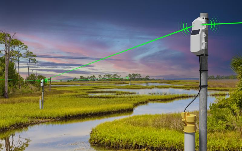
The HOBOnet remote water level monitoring system is an IoT solution that uses a cellular MicroRX station as its hub to wirelessly collect water level data from up to 50 remote sensor locations and deliver it to LI-COR Cloud in near real-time. It eliminates the need to physically visit sites to retrieve data, making it ideal for stream and wetland restoration, stormwater management, and groundwater monitoring projects with multiple monitoring points.
The HOBOnet sub-GHz wireless mesh technology provides a line-of-sight range of 1,500 to 2,000 feet (approximately 450–600 m) between sensors and the base station. This range can be extended further by hops, other sensors, or adding wireless repeaters, allowing monitoring across large wetland areas, multiple stream reaches, or distributed well networks from a single cellular station.
HOBO water level sensors use temperature-compensated pressure transducers with accuracy of ±0.05% FS (full scale). Temperature compensation is built in to prevent thermal drift from affecting pressure readings — a critical requirement for long-term deployments where ambient water temperatures fluctuate significantly.
The HOBOnet remote water level system is widely used for:
No — that is the core benefit of this system. The HOBOnet wireless sensors transmit data to the central cellular MicroRX station, which automatically uploads readings to LI-COR Cloud. You access all your site data remotely from any device via the cloud dashboard without any site visits required for routine data collection. Alerts can also be configured to notify you when water levels exceed user-defined thresholds.
The heart of the system,the RX2106 MicroRX station, as well as the HOBOnet water level sensors, use built-in solar panels, making it self-powered for continuous field deployment without grid power. The wireless water level sensors also use AA rechargeable, user-replaceable batteries. This solar-plus-battery design makes the system suitable for remote locations — wetlands, stream banks, and agricultural sites — where AC power is unavailable.