Image


As the lifeblood of our planet, water flows through every aspect of our lives. And with climate change impacts on the rise, the need for effective water level monitoring is more critical than ever – but not just when it comes to floods and drought. Let's get our feet wet with a closer look at water level monitoring, a key player in understanding, protecting, and conserving our most precious resource - water. But first...
Water level simply refers to the level of water in any body of water - from wetlands to water tanks. Technically, water level refers to the height or elevation of water above (or below, less common) a specified point. Where and how we determine water level and how we track changes in water level launches us into the diverse world of water level monitoring.
Water level monitoring is the systematic measurement and tracking of the height or depth of water in a particular location over time.
The location and application of how we monitor water level has led to many other terms commonly associated with the systems and strategies used to measure it.
For example, hydrologists tracking river or stream flows use the term gage (gauge) height, which refers to measurements taken at a streamgage or river gage station. A streamgage can be as simple as a hand-painted staff gage (aka stake) or as advanced as a wireless water level logger in a stilling well, where a submerged sensor transmits data via a cable to an above-water Bluetooth logger that includes a barometric pressure sensor.
A few other measurement terms you might hear around the water level cooler:
This is a big one in groundwater monitoring. When tracking in-ground water levels and water tables, hydraulic head refers to the height of a column of water above a specified reference elevation, such as sea level.
When measuring depth in a groundwater well, depth refers to the distance from the land surface to the top of the water in the well. When measuring depth in water tanks or surface water, depth is the distance from the water's surface to a specific point below, typically the bottom or the where the sensor is located.
Often located on a dock or pier post, tide gages monitor changes in sea level, and are sometimes deployed using a stilling well that's designed to let water flow in and out while dampening turbulence and protecting the sensor from debris.

Water level monitoring provides critical data that helps researchers, policy makers, and authorities make informed decisions about water-related issues. Amidst a sea of water level monitoring applications, here are some important ones:
Tracking water levels in reservoirs, rivers, and lakes gives decision-makers the crucial data they need to plan for drought conditions and implement management strategies for farming, communities, drinking water availability, electricity generation from dams, and more.
Successful wetland mitigation efforts involve tracking water level data in order to maintain appropriate water levels that support diverse plant and animal species and prevent habitat degradation. One conservation organization in Illinois, for example, studied water level to determine the significance of impacts from rainfall events on a 65-acre wetland area.
An ecosystem-based solution for stormwater management, green infrastructure strategies play a key role in mitigating risk and ecological losses that can occur due to urban development and the use of pesticides & fertilizers. Monitoring water levels can help assess things like the effectiveness of infrastructure projects to remediate runoff, issues in existing stormwater systems, and more.
Growers monitor water level in water tanks, irrigation canals, and reservoirs as part of their irrigation system monitoring efforts to reduce high operating costs while complying with water use regulations.
Monitoring water level supports sustainable groundwater management that can help prevent over-extraction, saltwater intrusion, and other issues related to improper groundwater use.
The number of water level monitoring applications can seem endless. The options for measuring it? That's a conversation in and of itself.
That's a question that’s not easily answered! Water level monitoring technologies continue to evolve, ranging from basic float & tape systems all the way to advanced satellite altimetry systems that support large-scale monitoring of oceans and seas.

However, throughout the world, experts in many fields rely on fairly simple monitoring solutions to get the crucial water level data they need. Hydrologists, environmental scientists, dam managers, researchers, civil engineers, fisheries biologists, regulatory agencies, growers, agriculturalists...even homeowners...get the job done with simple data loggers (also called water level transducers). Here's some basic info on different transducer types:
measure the force the liquid places on the surfaces in contact with it by calculating the water column's pressure above the transducer and converting it to feet of water column. Because atmospheric pressure on the water is also picked up by the sensor, transducers need a way to compensate for this barometric pressure when measuring below the surface of the water.
use venting to compensate for that barometric pressure, measuring the difference between two points in the water where the pressure is different from atmospheric pressure.
measure barometric pressure AND water column pressure together, without venting, and can require additional calculations using data from an external barometric sensor to get a compensated reading.

The options for accessing water level data have grown immensely over the past decade or so. With the arrival of Bluetooth wireless, sensor networks, and remote monitoring solutions, you can now decrease the time and costs associated with manually downloading data in the field. So, for water level monitoring, you have a range of choices. Depending on the application, each solution offers different benefits.
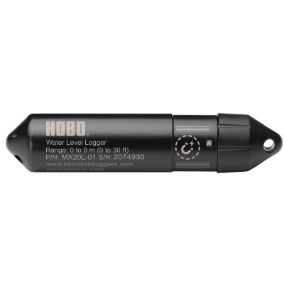
- These small, self-contained devices, like the affordable, research-grade HOBO U20L Water Level Data Logger, are non-vented for easy deployment, and utilize direct optical USB communication to download data directly to a base station or computer in the field.
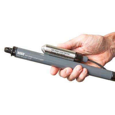
- Using wireless Bluetooth communication for setup and data offload, loggers like the HOBO MX2001 Water Level Data Logger offer a time-saving, convenient solution that also integrates a barometric pressure sensor so you get a direct-read measurement. For water level & water quality monitoring, the new HOBO MX800 Multiparameter Water Quality Bluetooth Data Loggers measure conductivity/salinity, temperature, depth (CTD), and dissolved oxygen (DO), all with one modular platform.
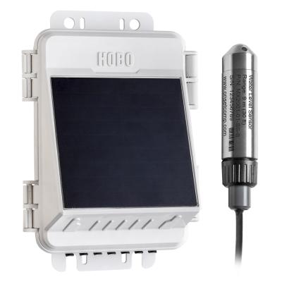
- Using a reliable cellular signal, remote monitoring stations send real-time water level data to the cloud for anytime/anywhere data access that reduces the time and cost of data collection. These systems can also be configured to send text/email alerts, and even integrate with industry analysis tools. Plus, they work with a range of wireless sensors to measure additional parameters, like soil moisture, temp/RH, and wind speed & direction. Check out the HOBO MicroRX Water Level Station and the HOBOnet Remote Water Level Monitoring System.
The bottom line with water level is that there's a deep pool of options to get the data you need to make informed decisions - to predict and manage impacts from floods or drought, promote sustainable resource management, improve irrigation practices, ensure dam safety, and better understand and mitigate the impacts of climate change.
If you need help understanding or deciding, just contact us and we’d be happy to work with you to customize a water level monitoring solution that’s sure to meet your specific application needs!